Birds of Bristol Bay

Birds of Bristol Bay

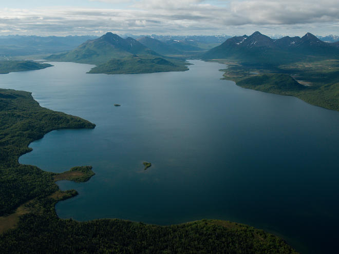
The beauty and bounty of Bristol Bay is unparalleled. Set on Alaska’s southwest coast, Bristol Bay’s network of rivers, lakes, and streams are known for producing salmon, but also support wildlife species of all kinds—including birds. While you’ll see plenty of gulls and geese in Bristol Bay, with more than 190 bird species, there’s a lot more to the story.

Here are just six of the magnificent birds of Bristol Bay:

American Dipper

This rotund little bird is America’s only aquatic songbird. About the size of a robin, American dippers do dip into rivers and streams -- even swimming underwater -- to find a meal. Their thick coat of feathers is covered in waterproof oil, helping repel frigid Alaskan waters all year round.

Red-Throated Loon

This water bird is the smallest member of the loon family. In summer you’ll find them in Bristol Bay’s lakes; in winter they prefer the ocean. During the breeding season, the loon’s neck changes from white to vivid red, matching its red eyes.

Willow Ptarmigan

The willow ptarmigan is Alaska’s state bird. This chicken-like animal dwells in Bristol Bay’s lowlands and changes its color every year. In summer, the ptarmigan is brown; in winter it’s bright white.
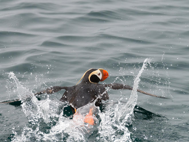
Tufted Puffin

You’ll know a tufted puffin by its prominent tuft of hair-like feathers on either side of its bright white face. But this is only a summer look. In winter they sport dark plumage and lose the tuft.

Red-Faced Cormorant

The red-faced cormorant, with its distinctive red bare-skinned face, is a year-round resident of Bristol Bay. During breeding season, it comes ashore and mingles with other species of seabirds while it nests on rock ledges and slopes.

Bald Eagle

Bald eagles are common in Bristol Bay year-round thanks to the plentiful supply of salmon. Even when populations plummeted in the lower 48 states, bald eagles held strong in Alaska thanks to clean, unspoiled environments like Bristol Bay. And they continue to thrive; there are more bald eagles in Alaska than in all the lower 48 states combined.

All these animals and so many more rely on Bristol Bay as one of America’s few remaining pristine wild places. But for more than 10 years, conservation organizations and local communities have fought tooth and nail to keep Bristol Bay undisturbed by industrialized mining. Pebble Mine, a proposed gold and copper mining operation, would cut a mile-long, quarter-mile-deep gash through the headwaters of Bristol Bay. The mine would also require extensive transportation and energy infrastructure and produce around 1.1 billion tons of waste during its 20-year operation. Bristol Bay, and the wildlife it supports, would be marred forever.

And the damage wouldn’t stop at Bristol Bay.  The mining company plans to construct an 83-mile corridor all the way to Amakdedori Beach on Cook Inlet. This would jeopardize marine mammals, the world’s largest concentration of brown bears, and seabirds like puffins, cormorants, and murres.

After years of victories and setbacks in this fight, we are now at a critical moment. The federal government is attempting to fast-track Pebble Mine, disregarding fundamental concerns about its environmental impacts. If we’re going to stop Pebble Mine, we need your help. Join hundreds of thousands of Americans who have already been loud and clear about their stance on our shared national treasure: no Pebble Mine in Bristol Bay -- not now, not ever.


Published May 30, 2019 at 05:00AM

Protecting the Peruvian Amazon

Protecting the Peruvian Amazon

Alfredo Ferreyros has seen flocks of macaws soar over the Peruvian Amazon rivers, their bright feathers creating a rainbow against the sky. He’s risen before sunrise many times to trek to the lakes where elusive giant river otters play. And he’s even spotted jaguars dozing on fallen trees at river’s edge in the Amazon forest.

As the first person to create an ecotourism company in Peru, 44 years ago, Ferreyros has seen most of the natural wonders of the Peruvian Amazon that are on tourists’ bucket lists. But he’s also witnessed growing challenges in the Amazon—mainly in the form of deforestation. The highest annual deforestation totals on record in the country have been over the past four years.

One of the best ways to stop deforestation—which negatively impacts the work of Ferreyros and people whose livelihoods depend on a healthy environment—is to ensure there’s long-term funding to properly manage the country’s national parks. The parks, most which are in the Amazon, are referred to on paper as “protected areas.” However, they can’t truly be protected from illegal loggers—or wildlife poachers, illegal gold miners, and others who see dollar signs in Peru’s forests—if there is not enough money to manage them well.

That’s why Ferreyros, who has helped the government design the country’s network of protected areas, is excited about a new initiative to fund the expansion and effective management of these important places in Peru. Through National Parks: Peru’s Natural Legacy, $140 million will be earmarked to permanently protect nearly 41 million acres in the Peruvian Amazon. On May 24th, partners supporting the initiative were in the Amazon to celebrate the commitment of the majority of this funding and meeting all of the conditions necessary to use the funding. 

Funding for the Government of Peru-led initiative comes from the Government of Peru, WWF, Gordon, and Betty Moore Foundation, Amazon Andes Fund and the Global Environment Facility. It will be used for such things as equipment and training.  

This is a milestone not just for Peru, but for the greater Amazon. The Peru initiative joins two similar ones in Brazil and Colombia. Together these three initiatives will permanently protect approximately 12% percent of the Amazon.

Protected areas in the Peruvian Amazon are critical to the health and strength of the country’s environment and economy. The forests within them, for example, have the potential to sequester nearly 50% of the estimated emissions from deforestation in the Peruvian Amazon. They also help boost the economy—mostly in the form of revenue from tourists who come to see Amazonian wildlife. Job opportunities, too, are greater for the people living in or adjacent to Peru’s protected areas than those living in natural resource-rich areas that are not protected.

Well-managed protected areas help ensure these benefits and many more can be realized now and well into the future.


Published May 24, 2019 at 05:00AM

New technology helps WWF and partners study whales in one of the most remote places on the planet

New technology helps WWF and partners study whales in one of the most remote places on the planet

Antarctica is epic—one of Earth’s last truly wild places. And new technology is teaching us more than ever before about one of the continent’s most enchanting creatures: whales.

WWF and our partners at Duke University Marine Robotics and Remote Sensing Lab (MaRRS)Friedlaender Lab, and California Ocean Alliance are using drone photography and digital tags to better understand how and where whales in Antarctica feed, the health of their population, and how climate change is affecting them.

The Antarctic Peninsula is a crucial spot for humpback and minke whales to feed on krill—the keystone species of the Antarctic food web. Despite its minuscule size, krill feeds far larger animals, such as penguins, seals, seabirds, and fish. An ocean current flowing clockwise around the content and north up the Western Peninsula brings swarms of these critters.

However, as oceans warm and sea ice declines, krill is on the move toward lower latitudes—farther south—requiring whales to travel longer distances to feed. Unfortunately, krill fishing is concentrated in this area and overlaps with crucial feeding areas for whales and other krill-dependent species.

As climate change is impacting the region, any increased competition with a growing fishery means we need to ensure that krill is harvested responsibly in this fragile habitat.

Drones and digital tags are helping us to better track and study humpback whales—how they eat, whether they’re healthy, and how climate change impacts their lives. We’re understanding more about the distribution and habitats of other krill-dependent species with these tools, too. Seals and penguins need those tiny critters to survive and share the same resting and breeding habitats. Artificial intelligence and machine learning techniques are used in processing drone images to count local populations. They're a game-changing technology. 

Collaboration is the spirit of Antarctic science and it’s the most effective way to make an impact. Across WWF, we work with a range of research teams including University of California Santa Cruz, California Ocean Alliance, Duke University, British Antarctic SurveyAustralian Antarctic Division and other partners such as tourism operators like One Ocean Expeditions working side-by-side in the field while sharing the science in action as it happens. 

The good news is governments have already committed to the creation of a network of Marine Protected Areas, an important piece of WWF’s goal to protect 30% of the Antarctic Peninsula by 2030. These Marine sanctuaries help build resilience to climate impacts and acts as an insurance policy for nature. These new technologies and innovative data allow us to make sure we can safeguard Antarctic wildlife for years to come, while we work to bring down global emissions that are causing Antarctica to warm, learn how you can reduce your carbon footprint. These new technologies and innovative data allow us to make sure we can safeguard Antarctic wildlife for years to come.

Imagery in this story collected under research permits: ACA #2015-011, #2016-024 & #2017-034; NMFS #14809; US NSF #1440435 & 1643877.


Published May 21, 2019 at 05:00AM

Just one-third of the world's longest rivers remain free-flowing

Just one-third of the world's longest rivers remain free-flowing

Only a little more than one-third of the world’s 246 longest rivers remain free-flowing, drastically reducing the diverse benefits that healthy rivers provide to people and nature everywhere, according to a new study by WWF and partners.

A team of researchers from WWF, McGill University, and other institutions studied about 7.5 million miles of rivers worldwide to determine whether they’re well connected. They found that only 37% are free-flowing—meaning they’re largely unaffected by human-made changes to its flow and connectivity. Dams built in the wrong place and climate change are impacting river health worldwide, and the planet’s remaining free-flowing rivers are largely restricted to remote regions of the Arctic, the Amazon Basin, and the Congo Basin.

VANISHING FREE-FLOWING RIVERS
Long free-flowing rivers are vanishing. Around the world, rivers are becoming increasingly fragmented by dams and other development—such as roads or dikes—endangering freshwater ecosystems and the people and wildlife that rely on them. Free-flowing rivers transport water, nutrients, and species that sustain biodiversity and benefit millions of people. To help countries and communities better protect their freshwater resources, WWF and partners came up with a technical definition of a free-flowing river and then created a first-of-its-kind, scientifically backed map—a comprehensive inventory of the world’s last free-flowing rivers, rivers with good connectivity and impacted rivers.

RIVER STATUS

MURA RIVER
SLOVENIA
Called the “Amazon of Europe,” the Mura River provides critical habitat for endangered and rare species such as otters, Danube salmon, and black stork. After urging from WWF and others, in February 2019, the Slovenian government signed an agreement to stop all hydropower plant development that would devastate the Mura.

USUMACINTA RIVER
MEXICO
In June 2018, guided by WWF and partners, Mexico established water reserves across nearly 300 river basins, guaranteeing water supplies for 45 million people for the next 50 years. Ninety-three percent of the water in the Usumacinta—the longest, most biodiverse river in Central America and one of Mexico’s—is now federally protected.

BITA RIVER
COLOMBIA
The Colombian government named the Bita River basin a Ramsar site—a wetland of international importance—in June 2018, thanks in large part to the work of WWF and partners. Covering 825,000 hectares, it’s the largest of the country’s 11 Ramsar sites and one of the few in the world to encompass an entire free-flowing river watershed.

PARAGUAY BASIN
BRAZIL
More than 100 dams planned for the Upper Paraguay Basin could hurt water supplies, biodiversity, and local communities. After tremendous efforts from a coalition including WWF, Brazil’s National Water Agency suspended new dam development there until May 2020. But the suspension only applies to rivers under federal jurisdiction—so just 20 of the 100 dams will be suspended.

LUANGWA RIVER
ZAMBIA
The Luangwa, which is free but impacted by a dam on a nearby river, is at risk. A proposed dam at Ndevu Gorge threatens this wild waterway, which shelters abundant wildlife and human populations. In Zambia, WWF is advocating on behalf of people and nature, pushing the government to reconsider its energy plans and ensuring that local people maintain their rights to natural resources.

IRRAWADDY AND SALWEEN RIVERS
MYANMAR
In Myanmar, an in-depth Strategic Environmental Assessment recommended that the main stems of the Irrawaddy and Salween rivers—two of the last long free-flowing rivers in southeast Asia—should remain free of dams. But there is still risk, making alternative energy such as solar and wind power even more important for people, rivers, and the country’s economy.

For more information on the study and WWF’s efforts to protect free-flowing rivers around the world, see free-flowing-rivers.org.

Free flowing rivers Infographic

FREE-FLOWING RIVERS
Download the full map >

MAPPING DAMS
Dams provide safe drinking water and electricity to millions of people. But when built in the wrong place—for instance, a river’s main stem—they can impede a river’s flow, causing drastic declines in biodiversity and affecting fish migration, agriculture, and livelihoods. Today there are more than 60,000 major dams around the world—a number that’s increasing to meet demand for hydropower. WWF is helping national governments, industries, and developers consider both the long-term impacts on local people and habitats and other potential alternative options for meeting water and energy supply needs, as well as helping them identify the best opportunities for river restoration projects. Solar and wind prices are going down, making them attractive alternatives.


Published May 09, 2019 at 05:00AM

Trailblazing women help ensure better tuna fishing in Ghana

Trailblazing women help ensure better tuna fishing in Ghana

Ocean conservation requires a solid understanding of what we’re taking out of our seas. How much fish do fishers catch? Where do they catch them? And what else are they catching along with the fish?

In Ghana, the government is seeking to answer those questions by collecting information digitally on tuna boats through a network of cameras, monitors, and sensors. That data provides guidance on how we can better care for our natural resources and reassures buyers that they’re getting a good catch. But that information is only useful if it’s analyzed. That’s where a few trailblazing women come in.

WWF’s Lauren Spurrier advocated for women to have access to jobs reviewing and organizing the information collected on boats—and she succeeded. Today, four of the 10 people tasked monitoring fishing in Ghana are women and this assignment provided the opportunity for them to pursue a professional future in a country with limited career opportunities. Ultimately, two of the women dedicated to the analysis work full-time accomplished 75% of the analysis.

 “As a woman, this project is an eye-opener for me,” said Agyeman Narkie Akua, an observer. “It boosts my strength because this is new, and I get to be a part of it. And in the future, I stand at a place where I can also educate other women if they have the desire to be part of something like this. We show them, ‘Hey, it’s possible.’”

WWF is working with the United Nations Food and Agriculture Organization and the Ministry of Fisheries and Aquaculture Development of Ghana to equip the purse seine tuna fleet—a collection of vessels that use lengthy nets to encircle large schools of fish—with electronic monitoring systems. Now observers like Akua can see exactly what is being taken out of the water, who is taking it, and where and when it’s happening. And it’s a safety net for vessel owners who can guarantee the market that their crews follow the rules.


Published May 02, 2019 at 05:00AM

Description

We own the copyright of all the content and articles on world-visits.blogspot.com. Any republish and editing of the articles for commercial use without our permission is strictly prohibited, although you can share the content any where on social network sites. Maximum images use in here not under our copyrights and belong to their respective owners. The images we collect from different free use sources. If you think any graphics or images is offensive or under your copyright and you no longer willing to show it in here than please email us at newblogfame@gmail.com. to get it removed.